See Your Entire Operation at a Glance
Live, color-coded trip and vehicle dashboard. Know exactly where every vehicle is and identify potential delays before they happen.
Traffic Alert
Heavy congestion on I-95

Where Fleets Struggle Without InstaMap
Common Challenges
Scattered Operational Data
Dispatchers waste time jumping between systems, calls, and spreadsheets.
Slow Issue Detection
Late trips or delayed flights are noticed too late, causing missed pickups.
Limited Situational Awareness
No unified map to see where every vehicle is in real time.
Reactive Problem-Solving
Teams respond to issues after they escalate instead of acting proactively.
What is the InstaMap?
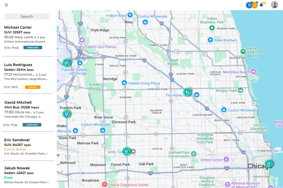
The InstaMap is a web-based, always-on dashboard that displays every trip, vehicle, and flight at a glance. Trip rows and pins change color in real time as risks emerge (late jobs, delayed flights, unassigned trips), so dispatchers can step in before issues escalate.
How InstaMap Keeps Dispatch Ahead
Live, Always-Current Trip View
What it does
See every active, pending, and completed trip with updates every few seconds; keeping dispatch fully aware without manual refresh.
How it works
Vehicle locations and trip statuses sync from the dispatch board and driver app every 5 seconds. The map automatically refreshes to show current positions, ETAs, and status changes without any dispatcher action.
Why it's Unique
Most dispatch maps show static snapshots or require manual refresh. InstaMap updates automatically every 5 seconds, so you always see the current operational state without clicking anything.
Color-Coded Vehicle Pins
What it does
Pins shift color by lateness, status, or risk; so potential issues stand out instantly and no dispatcher is left guessing.
How it works
The system calculates real-time lateness based on scheduled vs. actual times. Pins automatically change color: green (on time), amber (5-15 min late), red (15+ min late or at risk). Unassigned trips show as gray with urgent indicators.
Why it's Unique
Generic maps show all vehicles the same way. InstaMap's color-coding instantly highlights which trips need attention—green (on time), amber (slightly late), red (at risk)—so problems are visible at a glance.
Integrated Flight Overlay
What it does
View delays, gate changes and arrivals right on the map; reacting instantly without juggling multiple systems or lookups.
How it works
Flight data from aviation authorities syncs automatically. When a flight is delayed or gate changes, the map shows updated arrival times and gate information directly on airport pins, with color indicators for delays.
Why it's Unique
Other systems require switching between flight trackers and dispatch maps. InstaMap shows flight status directly on the map, so you see gate changes and delays in context with your vehicles.
Auto-Surfaced At-Risk Jobs
What it does
Unassigned or late jobs are flagged automatically with urgent color codes, so nothing critical gets missed.
How it works
The system continuously monitors trip status against SLA thresholds. Unassigned trips, late pickups, and delayed flights trigger automatic visual alerts—red pins, highlighted rows, and urgent indicators—so dispatchers can't miss critical issues.
Why it's Unique
Legacy systems rely on dispatchers to spot problems. InstaMap automatically flags unassigned trips, late pickups, and delayed flights, ensuring nothing falls through the cracks.
Instant Trip & Driver Details
What it does
Click any pin or trip row to see live driver location, ETA, route, and trip info; ready in seconds when decisions matter.
How it works
Clicking any vehicle pin or trip row opens an instant detail panel showing driver name, current location, real-time ETA, route preview, passenger details, and trip notes. All information loads instantly from the integrated dispatch system.
Why it's Unique
Most maps require multiple clicks or separate windows to see trip details. InstaMap shows everything in one click—driver location, ETA, route, passenger info—so you can make decisions instantly.
InstaMap Questions
Explore More Capabilities
InstaDispatch
The central nerve center for your operation. InstaDispatch unifies order entry, driver tracking, and automated client communication while flagging operational risks before they impact your customers.
Driver App
Mobile app with automatic check-ins, GPS tracking, and push-to-talk communication
Branded Website + SEO
Professional branded sites that rank
Ready to stop the chaos?
Join hundreds of transportation companies running on InstaRoute. Setup takes less than 5 minutes.